Shetland is an ideal walking destination for inexperienced nature walkers, because it is almost impossible to get lost. I have never used a compas or followed an Ordnance Survey map, but I have no problem orienting myself to a coastline. We managed to explore a fair bit of Shetland, mostly on the track of stones in some form or other, and although we didn't always have the easiest time finding our destination, we were never in any danger of losing our way.
Jarlshof
The first stop was the easiest to find. We crossed the airport runway at Sumburgh (after waiting for a plane to take off right in front of us) and arrived at Jarlshof with its Neolithic, Bronze Age, Iron Age, Norse and Medieval settlements. Lots and lots of lovely stones! The guides all said it was closed during the winter season (October to March), but a fellow Wool Weeker informed us that we could get tickets and audio guides at the Sumburgh Hotel next door.
 |
| Drystone constructions at Jarslhof |
Brochs
The broch at Jarlshof and the easily accessible Clickimin Broch in Lerwick whet our appetite to see more of these amazing Iron Age round tower structures (only found in Scotland). Unfortunately we were not able to see the most stunning Mousa broch except from a distance, because boat trips to the island are off during the winter season, so we set off to find another one on the West Mainland. A not very helpful sign on a gate said Culswick broch was 1.5 km away. Two km later and no broch in sight, we headed off for a view of the coast.
 |
| Culswick coast |
It was only after we had turned around and were on our way back that I spotted the broch in the far distance. Unfortunately we had to get to a Wool Week event in Lerwick, so we didn't have time to walk any closer, but it was an impressive structure, even from a distance.
 |
| Found the broch! |
Unst
We took a day trip out to the island of Unst, mainly to visit the most northerly island in the UK... and the Unst bus shelter.
 |
| Unst bus shelter decorated for Wool Week |
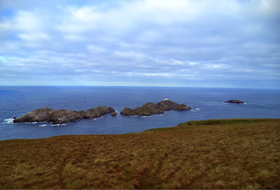
We tramped across the Hermaness National Nature Reserve to see the islands at the very tippy top of Britain - Muckle Flugga with its lighthouse built by Robert Louis Stevenson's father (the map of Treasure Island is said to be based on Unst) and Out Stack (the "full stop at the end of Britain"). The nature reserve has put in a plank boardwalk out to the coast, so you don't have to slog through too much bog, though you have to walk a bit farther along the coast to see the islands. Most of Shetland is boggy peatland, so be prepared with hiking boots - and roll up your trouser legs!
 |
| Muckle Flugga and Out Stack. Great place for bird watching - must remember the binoculars next time! |
Stones of Stofast
On our final day we went for one more walk, to find the Steens, Stanes or Stones of Stofast, a large rockpile carried by a glacier and dumped on the Lunna Ness peninsula. My various pieces of tourist literature mentioned the general location, so we decided to walk out and see what we could find. After an hour tramping over cake and slogging through tea (pretty much what walking on bog feels like) we decided we must have gone in the wrong direction and headed back.
We passed a rocky beach with a view of seals sunning themselves on a little island so did not regret the detour.
 |
| Watching seals and quite annoyed by now about those forgotten binoculars. |
And then driving away from the coast we spotted a sign we had overlooked earlier, pointing toward the stones. So we had to get out again and tramp through some more bog. The extra walking was well worth it - the stones are only about 30 minutes from the road, and very impressive.
 |
| Finally, the stones! |
 |
| Now that is what I call a stone! |
 |
| Obelisk and sphinx? |
After we got back from Shetland we discovered the very useful Walk Shetland website, which would have saved us a lot of time and trouble if we had bothered to prepare for our walks in advance. On the other hand, getting lost can offer other delights, and there is the sense of accomplishment when you find something on your own.

No comments:
Post a Comment